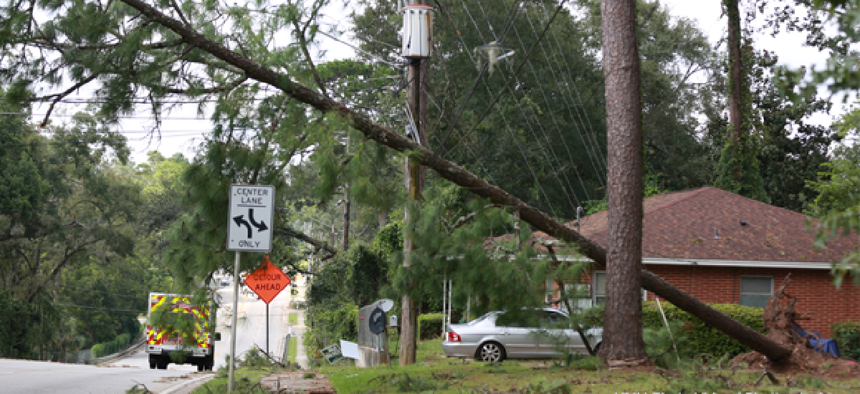
Predicting power outages from soil moisture data


Connecting state and local government leaders
With data on soil moisture collected from a NASA satellite, researchers were able predict power outages with 91 percent accuracy five days before Hurricane Matthew raked the East Coast in early October.
Most electrical outages are caused by falling trees or limbs bringing down power lines. After a major storm, it may take weeks to fully restore power. Fortunately, scientists are getting better at predicting where and when such damages is likely to occur, which gives utility companies and emergency workers a head start on hurricane response.
The trick, according to Steven Quiring, professor of atmospheric sciences at Ohio State University, is combining analysis of wind and soil moisture data. Trees are far more likely to be blown over if the soil in which they are rooted is soaked. And conversely, drought conditions make trees limbs brittle and more likely to be broken during a wind storm.
Quiring -- along with colleagues Seth Guikema at the University of Michigan and Brent McRoberts at Texas A&M -- has been working on predicting hurricane damage for the past 10 years. The addition of soil moisture data from NASA’s Soil Moisture Active Passive (SMAP) satellite, however, made it possible for the team to predict power outages with 91 percent accuracy five days before Hurricane Matthew raked the East Coast in early October.
What’s more, the team’s predictive abilities should improve as the soil moisture data improves, Quiring said. NASA’s SMAP satellite was designed to collect soil moisture data using both radar and radiometers. Radar (the “active” technology) measures the backscattering of a transmitted microwave radio signal that is reflected off the ground, which varies depending on the water content of the surface. Radiometers (the “passive” technology) measure the microwave radiation emitting from the surface.
Unfortunately, shortly after achieving orbit, the SMAP satellite’s radar malfunctioned and couldn’t be restored. As a result, the team’s analysis prior to Hurricane Matthew relied solely on the radiometer’s soil moisture data, which was then analyzed along with data on population density, land use, wind speeds and storm characteristics to generate the forecast model.
“The advantage with radar is the capability to get very high spatial resolution,” Quiring said. Radiometers, on the other hand, generate more accurate moisture measurements, but the spatial resolution is “a lot coarser,” he said. Specifically, the spatial resolution of the radar device is 3 kilometers, while the radiometers are only 36 kilometers. Fortunately, Quiring said, improvements in software are expected to increase the radiometer’s resolution to about 9 kilometers. “That is ultimately what we will use,” he said.
The accuracy of the team’s prediction model also varies by geography. “There is a spatially generalized model that we can run for anywhere in the United States,” Quiring said. The generalized model depends on publicly available datasets, which resolve down to census tracts. “We also have other versions of the model that are ‘utility specific.’ For those, they are often run at higher spatial resolution and can incorporate information that is provided by the utility.” That information may include customer locations and information about the utility’s infrastructure. In some cases, the team can even include the exact coordinates of poles and transformers.
Another opportunity to improve predictions further is in expanding the sources and frequency of data collection. Currently, the team gets storm data from the National Hurricane Center every six hours. But there is a 24-to-48 hour lag in the soil moisture data once it is gathered by the NASA SMAP satellites. What’s more, the satellite passes over a particular location only once every three to five days.
“In the worst case, the soil moisture data could be a week old,” Quiring said. Fortunately, he said, that’s not as big a problem as it might seem. “With the exception of a strong marine band in advance of landfall of hurricanes, soil moisture is relatively stable,” he said.
Still, Quiring said that staff scientists on the project -- which is funded by the Department of Energy, the National Science Foundation and a private utility -- are working on combining radar data from other satellites with the radiometer data from SMAP to improve accuracy and timeliness of the data.
And while he doesn’t actually want to see any communities afflicted with hurricanes, Quiring said that more storms would allow researchers to improve their models. “Hurricane Matthew was our first opportunity to utilize SMAP for a major hurricane the United States, and it's difficult with a sample size of one to make strong statements about how much improvement we have made.”