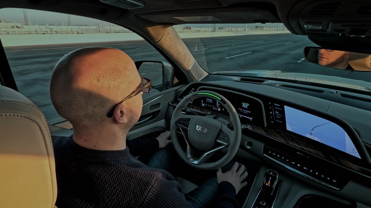
A driver’s hands rest loose in their lap while the wheel turns itself through a highway curve.
Above that wheel, a tiny dark lens never blinks. It watches the driver’s face, not the road.
Outside the windshield, the lane lines matter less than an invisible map loaded months earlier, and that map, not the camera out front, decides where this car is allowed to let go.
How a car actually knows which roads it can drive hands free
The trick behind General Motors’ Super Cruise is not a smarter windshield camera, it is a library. Before any driver ever takes their hands off the wheel, survey vehicles equipped with laser scanners have already driven that exact stretch of highway, recording its exact lane geometry and curvature down to inches.
That scan becomes a high precision digital map stored in the car. GM was the first to adopt such maps and contracted with a company then known as Ushr to do high-resolution lidar scans of divided highways throughout the US and Canada. Ushr has since been acquired and rebranded as Dynamic Map Platform, and it still provides the Super Cruise maps. In addition to lane level data, the maps also include other geometric information such as the radius of curves and topography. That data gets loaded into the car alongside GPS and real time camera and radar input.
So the car is not really improvising its way down the highway. It is checking live sensor readings against a pre built reference map, and if the road ahead was never scanned, hands free mode simply will not turn on, no matter how clear the lane markings look.
Inside the cabin, a second system is watching the driver, not the pavement
While the car handles steering and spacing, a separate infrared camera sits on top of the steering column with one job: proving the driver is still paying attention. A small infrared camera mounted on the steering column tracks head position and eye movement to confirm the driver is facing forward and paying attention.
That camera does not record video for later review. The Driver Attention Camera does not record or share photos, audio or video. By monitoring gaze, it lets drivers know when they need to look back at the road.
Look away too long, nod off, or turn to check something in the back seat, and the escalation sequence begins almost immediately, moving through visual, audio and haptic alerts before the car brings itself to a controlled stop, activates hazard lights, and calls for help. The Cadillac Super Cruise system uses FOVIO vision technology, developed by Seeing Machines, to enable a gumdrop sized infrared camera on the steering wheel column to accurately determine the driver’s attention state. This is accomplished through a precise measure of head orientation and eyelid movements under a full range of daytime and night time driving conditions.
The map has grown nearly six times since the system launched, and the numbers show why that matters
When GM launched Super Cruise in 2017, it had around 130,000 compatible highway miles. In 2022, that mileage figure jumped up to 400,000, and it has kept climbing since, most recently with a push into smaller connecting routes.
Growing to about 750,000 miles of compatible roads across the U.S. and Canada, including divided highways, major and minor highways. That single jump added more rural, two lane routes than the entire network held just a few years earlier.
GM likes to put that distance in human terms. The company says 750,000 miles is like traveling one way from Earth to the Moon three times, or taking a coast-to-coast road trip from New York City to San Francisco and back nearly 130 times.
A similar sense of scale shows up in how an Illinois assembly plant coordinates hundreds of robots across a single shift without stopping the line, and that latest expansion gave GM the largest truly hands-free operating domain in North America, nearly six times the coverage of other hands-free driver assistance technologies on the market today.
The map’s edge is also the system’s hard limit
None of this means the car can drive itself anywhere. The same geofencing that makes Super Cruise reliable on mapped roads is exactly what shuts it off the moment a driver leaves them, even onto a perfectly ordinary two lane road nearby.
That is a deliberate tradeoff against rival approaches that skip mapping entirely. No true self-driving cars are for sale in the U.S., though some automakers advertise similar systems under misleading names that suggest they can drive themselves. Some, like Tesla’s Autopilot system, work without maps and rely purely on the car’s sensors to function.
But GM’s engineers have argued that trading that flexibility for a verified map is what keeps the system predictable at highway speed. High precision LiDAR mapping gives us an operating domain where we are confident in Super Cruise’s abilities, according to Anantha Kancherla, GM vice president of ADAS. Even inside the mapped network, the driver camera can still shut things down fast.
Sun shining into the camera, dawn or dusk glare on the driver’s face, or cups, food, hands, or other objects obscuring the camera’s view all trigger the same alert sequence, regardless of how good the mapped road ahead actually is.
Why this gap between mapped and unmapped roads still matters to drivers
GM has said publicly it wants to eventually cover far more of the US road network, which would make more door to door trips possible without ever touching the wheel. Getting there means sending scanning vehicles down thousands of miles that have never been measured this precisely.
For now, the practical reality is that hands free capability stops exactly where the laser scan stops. That is worth knowing before a road trip, since the system’s confidence depends entirely on whether that stretch was ever driven and scanned first.
It also explains why shoppers comparing hands free systems, much like buyers weighing a used car’s history report against what actually happened to the vehicle, should ask exactly which roads are covered. The map, not the marketing mileage number, is what ultimately decides whether the hands actually get to leave the wheel.
